

The eruption is considered to be the deadliest and most economically destructive volcanic event in the history of the United States.
In 1982 the President and Congress created the 110,000-acre National Volcanic Monument for research, recreation, and education. Inside the Monument, the environment is left to respond naturally to the disturbance.
In 1982 the President and Congress created the 110,000-acre National Volcanic Monument for research, recreation, and education. Inside the Monument, the environment is left to respond naturally to the disturbance.
Visitor centers along highway 504 tell the story and provide stunning crater views. Trails let visitors explore the rebirth or access areas slower to recover.
Mount St Helens National Volcanic Monument is within the Gifford Pinchot National Forest. Numerous viewpoints and miles of trails have been created for you to explore by car and foot. During the summer Forest Interpreters lead a wide range of activities, from short walks to amphitheater presentations, to help you understand and enjoy this area.
The Gifford Pinchot National Forest offers lot's of recreational opportunities : camping, hiking, backpacking, mountain biking, climbing and caving.
The Gifford Pinchot National Forest offers lot's of recreational opportunities : camping, hiking, backpacking, mountain biking, climbing and caving.

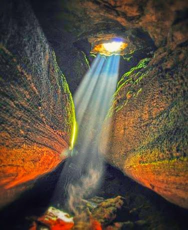
But most people are attracted to this area by Ape Caves - a lava tube formed when the surface of a lava flow cooled and hardened.
About 2,000 years ago lava poured down the southern flank of Mount St. Helens in streams. As the lava flowed the outer edges of the lava stream cooled forming a hardened crust which insulated the molten lava beneath. This allowed the lava to remain hot and fluid encased in this “lava tube” and continued flowing months during the eruption. The end result was the creation of this spectacular 13,042 long lava tube.

It is the longest lava tube ( 12,810 feet or 3.9 kilometers ) in the conterminous United States (similar tubes are found in Oregon, California, and Idaho).
There are two parts of Ape Caves : Low and Upper Caves.


The lower Ape Cave is approximately is .75 miles long and can be hiked down and back in an hour.

If you decide to explore the caves on your on, bring clothing layers: it’s 42˚ inside the lava tube. Wear rugged outer clothing, such as jeans, if you are going to crawl. Bring one headlamp and a spare flashlight per person; it is also advisable to rent a lantern at the Ape’s Headquarters ($5) - their lanterns have a wire mesh that protects the mantles, rather than glass, which could shatter in the cave. Wear protective gloves if you’re doing the Upper Cave. Camera lenses will fog over as you approach exits and vents. It takes about four hours to fully explore the entire lava tube.
After you're done exploring the caves, stop by another nearby attraction - Trail of Two Forests.


The cave is open year round. It's about 3 hour dive from Seattle. National Forest Pass is required to park in the area.
No matter what season it is outside, you can always find something to do in the area !
In winter, this area is famous for snowmobiling, cross country skiing, and snowshoeing.
In summer it offers amazing camping, hiking, biking, and boating opportunities.
The most adventurous opt for the "summit" ( or whatever is left of it :)). You can hike to the top in summer, or use snowshoes or touring skis in winter.
For more outdoor adventures, check out the posts below:
1 comment:
where in washington state are those caves located? I will be doing some traveling down there in 2010.
felix
Post a Comment